EU Space Data for Maritime Applications in ASEAN


GNSS.asia has brought together industry professionals in its EU-ASEAN workshop in March 2021. Speakers from institutional agencies and private businesses alike joined the discussion about the usage of EU Space Data for Emergency & Maritime Applications in ASEAN. The two-day event was a success with over 250 participants. This platform will be integrated as a long-term networking tool for the GNSS.asia community under the name GNSS.asia Hub and has already received great feedback after the event for its ability to connect different stakeholders and foster collaboration.
The EU and ASEAN look back on a long-standing record of cooperation, but this engagement has been stepped up further through recent agreements made in 2020 such as the Agreement for the EU-ASEAN Strategic Partnership and the cooperation for maritime security. The workshop resembles the desire for more intense cooperation between EU and ASEAN nations in the specific field of space, emergency, and essential data for marine purposes.
In this article, the potential for EU space data in maritime applications is discussed in front of the maritime opportunities and needs of ASEAN nations. Additionally, applications currently in use are introduced.
ASEAN Nations and Maritime
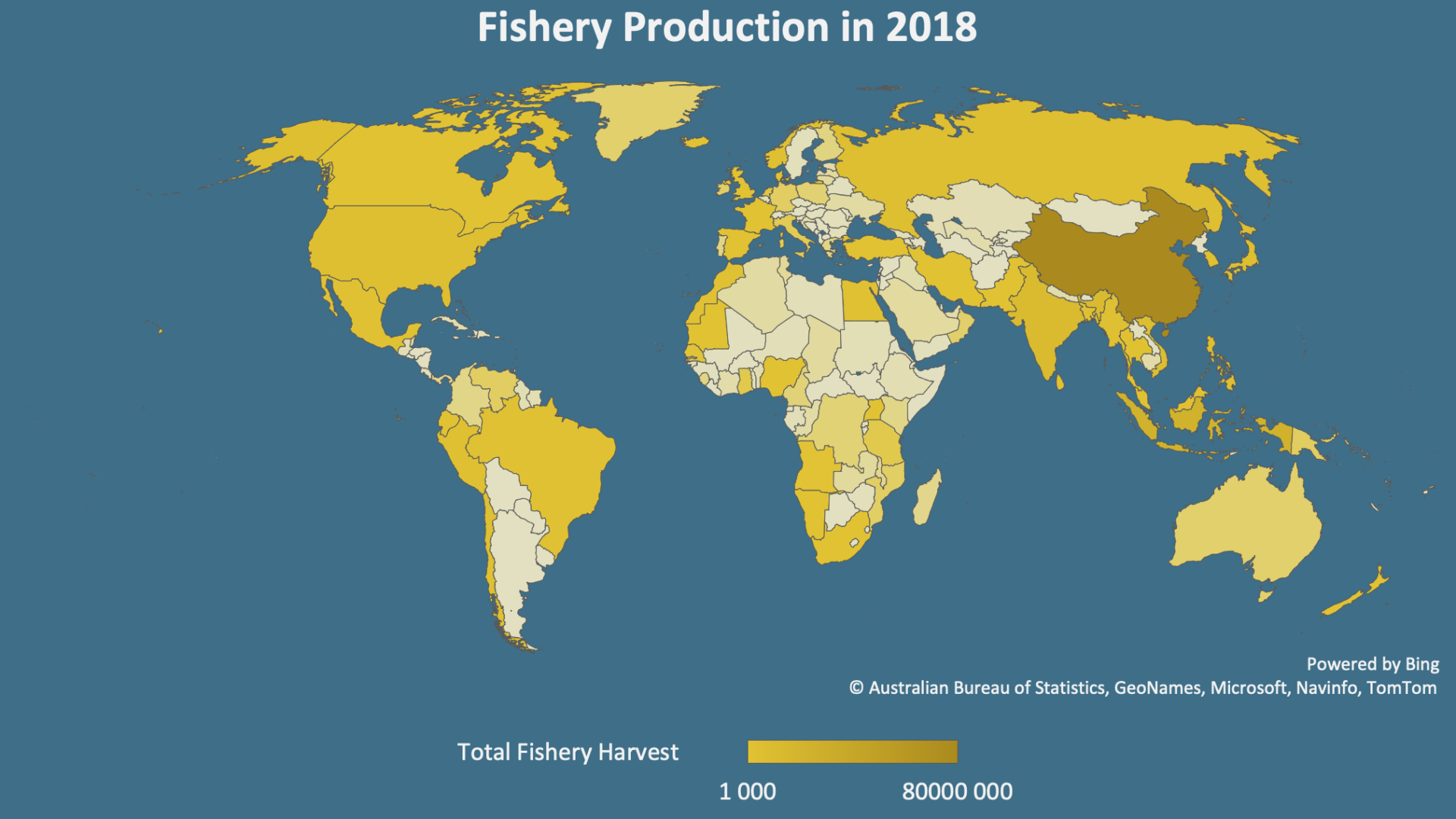
Southeast Asia is an economically, culturally, and strategically pivotal point between the Indian and the Pacific Ocean. Except for landlocked Laos, ASEAN nations have large coastlines that represent geographic maritime potential. Maritime transport is one of the key catalysts for socio-economic development and international competitiveness. But, also integral for economic integration within ASEAN, linking the nations closer together. As efficient ports are vital to the success of the whole value chain, their performance therefore greatly affects the countries’ productivity and effectiveness. This results in the need for developing the necessary infrastructure and enhancing its productivity through a variety of management tools. A strong opportunity for Space Data in ASEAN lies in the Fishery sector. Fishing is both a vital source of income and essential to the diets of the region, with seven of the top twenty most dependant countries on fishing being ASEAN member states when ranked by fishing captures as a percentage of GDP. This also makes Southeast Asia one of the largest producers of seafood. Increasing efficiency in this sector, therefore, represents a great lever for the growth of the ASEAN region.
Although some Southeast Asian countries already have a strong focus on the maritime domain, the interest varies widely from country to country, and thereby also the individual potential still to be leveraged. Maritime economic connectivity and shared interests in maintaining maritime commons have the long-term potential to unite the region, while still being one of the largest points of contention between the member nations.
Galileo for Maritime
With maritime activities also comes the danger of working in the powerful environment of the world seas. In order to guarantee the safety and efficiency of maritime sector employees, Galileo and EGNOS offer waterborne and emergency response applications to support the sector. Galileo, as a GNSS service is especially suited for its use in ships and was recognised by IMO in 2016 as part of the World-Wide Radionavigation system, allowing for its use in merchant shipping. The Open Service (OS) offers positioning, velocity and timing information that can be accessed free of direct user charge. With the help of the High Accuracy Service (HAS), this data can be obtained with an error smaller than two decimetres, especially suited for ship maneuvers. For governmental authorised users and sensitive applications, the Galileo Public Regulated Service (PRS) delivers encrypted navigation information with high continuity. Those applications can be deployed excellently to ensure the sophistication of navigation systems and increase the speed of operations through precise navigation. In order to push the performance further, EGNOS can be implemented as a satellite-based augmentation system (SBAS) to perform pseudo-range corrections, satellite and system alerts, and even better accuracy. Therefore, it would be of interest to use SBAS for ocean waters, coastal waters, and harbor, especially where there is no GNSS infrastructure or poor connections.
Copernicus for Maritime
Earth Observation (EO) offers a large number of possible marine environment and maritime navigation applications. The Copernicus applications are grouped into three main groups:
- Maritime Safety
- Environment
- Infrastructure at Sea
For each of these groups, the Copernicus Marine Environment Service (CMEMS) combines specific applications that aim to provide regular and systematic information about the physical state and dynamics of oceans through observations and forecasts. Within this service are over 130 products and to improve the reliability, SAR images are used as they can see through clouds and in darkness. CMEMS guarantees a new image every 2-4 days in the ASEAN region and offers the Sentinel services for free through open data. Through Sentinel-2 and Sentinel-3 water quality can be monitored.
Another service specific for governmental usage is the Copernicus Security Service that aims at improving crisis prevention, preparedness and response. It was created specifically for maritime surveillance and is managed by the European Maritime Safety Agency.
Ship detection
The Philippine Space Agency (PhilSA) uses satellite data for national security, disaster risk reduction, and management as well as coastal and ocean agriculture. They use Sentinel-1 data and connect it with an AI to detect ships within their jurisdiction. This is useful as ships in close proximity to each other in open water could be a sign for illegal activities (like smuggling) and it can show possible intrusion, for example into marine protected areas. The Malaysia Maritime Enforcement Agency (MMEA) goes one step further and cross-references these observations with a database to determine exactly what kind of ship it is.
Water Quality Assessment
In order to assess water quality, Sentinel-2 and Sentinel-3 data are used by PhilSA. The agency monitors Chlorophyll-a presence, which is a measure representative of algae abundance and they also observe turbidity, which represents pollution levels. This data combined with information about sea surface temperature can also be used to estimate the seasonal migration of fish.
Fishing and Habitat protection
Another application often employed is benthic habitat classification with the help of EO data, which is important to inform decision-makers about the areas that require protection or are suitable for fishing. Another upside for the fishery is that after the perfect areas for fishing have been determined through EO, the high precision GNSS navigation can inform fishers whether they are in the correct locations. Malaysia has reported an improved fishery yield by up to 50% through using these satellite applications.
Port Management and Ship Navigation
As ASEAN is home to some large regional ports, especially the Singapore port, the need for exquisite navigation systems is apparent. High accuracy GNSS data can be employed for pilotage operations in order to guarantee the safe entry of vessels into the port and on open waters, the service contains situational awareness systems and enables safe trajectory planning. Within the workshop, the exciting announcement was made by the European Union Agency for the Space Programme (EUSPA), that autonomous vessels based on Galileo are coming suitable for short-distance or inland waterways transport as well as automatic tugs and support for off-shore navigation. They also introduced their Hull to Hull (H2H) project, which addresses the need of the maritime community to safely navigate in close proximity to other vessels and objects. The service operates using 3D models and positioning measurements delivered by Galileo and EGNOS.
To conclude, the possibilities for EU Space Data in Maritime applications are endless and their prospects promising. Making sea transportation more efficient and marine ecosystem observation easier could not only lead to increased economic productivity, but also to more eco-conscious growth.
We would like to thank all of the amazing speakers and participants of the EU ASEAN workshop for emergency and maritime applications for sharing their ideas and opinions with us. In order to read about insights gained on emergency applications read up here.
If you would like to watch the presentations of our ASEAN speakers, you can find them here, and in case you are interested in industry testimonies, check out this playlist.
If you want to find out more about Galileo and its maritime applications do not hesitate to contact the GNSS.asia team at hello@gnss.asia or subscribe to our newsletter to stay up to date on the latest trends and developments.